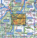
Wandelkaart - Topografische kaart 3335OTR Grenoble | IGN - Institut Géographique National (9782758551973)
Chamrousse, Belledonne
- ISBN / CODE: 9782758551973
- Editie: 07-02-2022
- Druk: 2
- Aantal blz.: 1
- Schaal: 1:25000
- Uitgever: IGN - Institut Géographique National
- Soort: Topografische kaart, Wandelkaart
- Serie: Top 25
- Taal: Frans
- Hoogte: 24.0 cm
- Breedte: 11.0 cm
- Gewicht: 81.0 g
- Bindwijze: -
- Uitvoering: Scheur- en watervast
- Schrijf als eerste een review
-
€ 21,95
Op voorraad. Voor 17.00 uur op werkdagen besteld, morgen in huis in Nederland Levertijd Belgie
Gratis verzending in Nederland vanaf €35,-
-
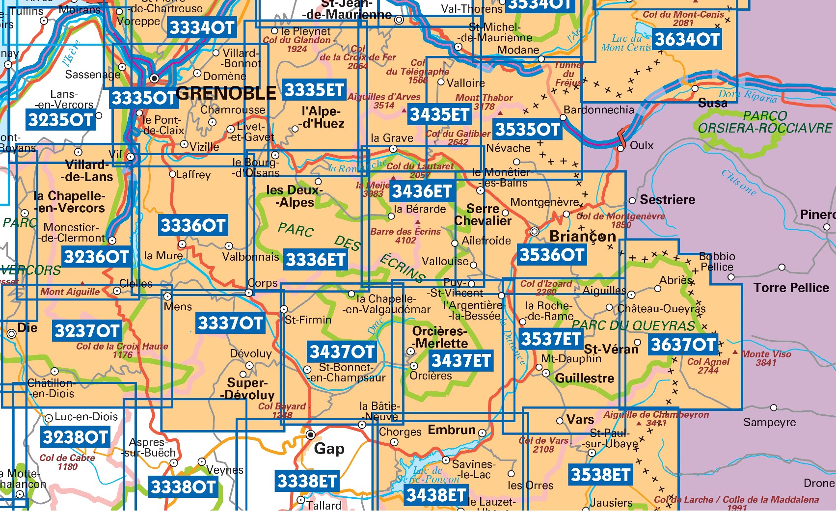
Topografische kaarten IGN 25.000 Hautes Alpes: Ecrins

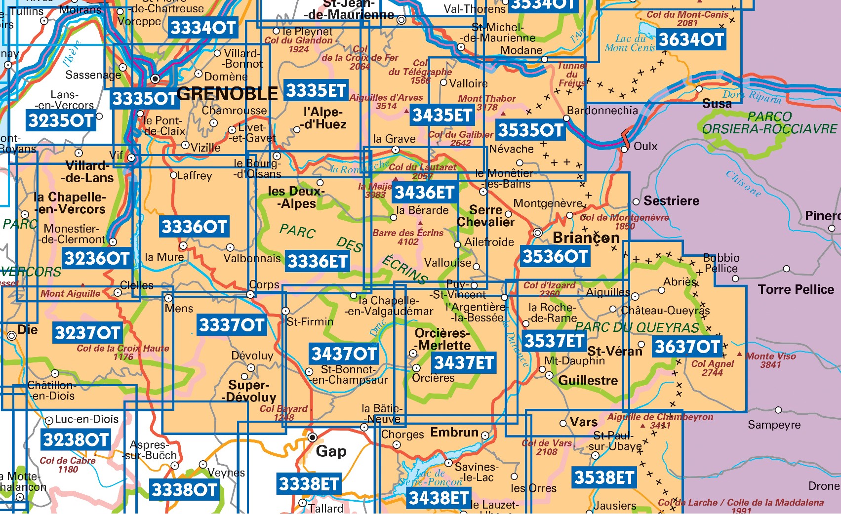
Producten op deze overzichtskaart:
Klik op een product om naar de pagina van dat product te gaan.
- Wandelkaart - Topografische kaart 3335OT Grenoble | IGN - Institut Géographique National
- Wandelkaart - Topografische kaart 3335OTR Grenoble | IGN - Institut Géographique National
- Wandelkaart - Topografische kaart 3336ET Les Deux Alpes | IGN - Institut Géographique National
- Wandelkaart - Topografische kaart 3336ETR Les Deux Alpes / Olan / Muzelle /PNR des Ecrins | IGN - Institut Géographique National
- Wandelkaart - Topografische kaart 3336OT La Mure | IGN - Institut Géographique National
- Wandelkaart - Topografische kaart 3337OT Dévoluy | IGN - Institut Géographique National
- Wandelkaart - Topografische kaart 3337OTR Dévoluy | IGN - Institut Géographique National
- Wandelkaart - Topografische kaart 3338ET Gap | IGN - Institut Géographique National
- Wandelkaart - Topografische kaart 3436ET Meije - Pelvoux | IGN - Institut Géographique National
- Wandelkaart - Topografische kaart 3437ET Orcières-Merlette | IGN - Institut Géographique National
- Wandelkaart - Topografische kaart 3437OT Champsaur | IGN - Institut Géographique National
- Wandelkaart - Topografische kaart 3438ET Embrun | IGN - Institut Géographique National
- Wandelkaart - Topografische kaart 3536OT Briançon | IGN - Institut Géographique National
- Wandelkaart - Topografische kaart 3537ET Guillestre | IGN - Institut Géographique National
- Wandelkaart - Topografische kaart 3538ET Aiguille de Chamberyron | IGN - Institut Géographique National
- Wandelkaart - Topografische kaart 3637OT Mont Viso | IGN - Institut Géographique National
-
Topografische kaarten IGN 25.000 Savoie - Vanoise
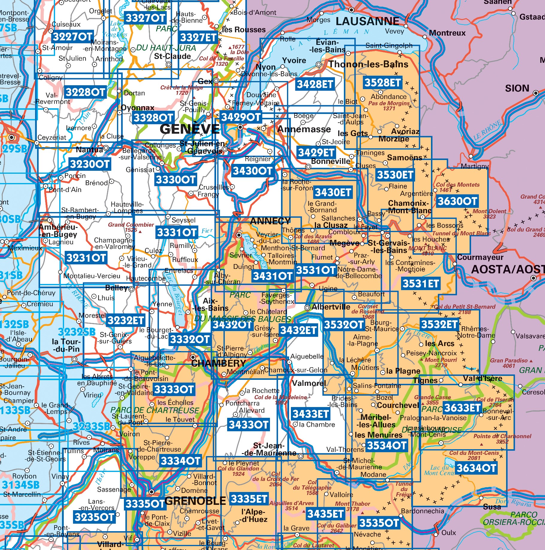
Producten op deze overzichtskaart:
Klik op een product om naar de pagina van dat product te gaan.
- Topografische kaart - Wandelkaart 3233 Le Grand-Lemps, Lac de Paladru, Voiron, Tullins | IGN - Institut Géographique National
- Wandelkaart - Topografische kaart 3333OT Massif de la Chartreuse Nord | IGN - Institut Géographique National
- Wandelkaart - Topografische kaart 3334OT Massif de la Chartreuse Sud | IGN - Institut Géographique National
- Wandelkaart - Topografische kaart 3335ET le Bourg d'Oisans - l'Alpe d'Huez | IGN - Institut Géographique National
- Wandelkaart - Topografische kaart 3335OT Grenoble | IGN - Institut Géographique National
- Wandelkaart - Topografische kaart 3335OTR Grenoble | IGN - Institut Géographique National
- Wandelkaart - Topografische kaart 3432ET Albertville | IGN - Institut Géographique National
- Wandelkaart - Topografische kaart 3432OT Massif des Bauges | IGN - Institut Géographique National
- Wandelkaart - Topografische kaart 3432OTR Massif des Bauges | IGN - Institut Géographique National
- Wandelkaart - Topografische kaart 3433ET Saint-Jean-de-Maurienne | IGN - Institut Géographique National
- Wandelkaart - Topografische kaart 3433OT Allevard | IGN - Institut Géographique National
- Wandelkaart - Topografische kaart 3435ET Valloire | IGN - Institut Géographique National
- Wandelkaart - Topografische kaart 3532ET les Arcs - la Plagne | IGN - Institut Géographique National
- Wandelkaart - Topografische kaart 3532OT Massif du Beaufortain | IGN - Institut Géographique National
- Wandelkaart - Topografische kaart 3534OT Les Trois Vallées | IGN - Institut Géographique National
- Wandelkaart - Topografische kaart 3535OT Névache - Mont Thabor | IGN - Institut Géographique National
- Wandelkaart - Topografische kaart 3633ET Tignes - Val d'Isère | IGN - Institut Géographique National
- Wandelkaart - Topografische kaart 3634OT Val Cenis | IGN - Institut Géographique National
-
Wandelkaarten IGN 25.000 Hautes Alpes: Ecrins

Producten op deze overzichtskaart:
Klik op een product om naar de pagina van dat product te gaan.
- Wandelkaart - Topografische kaart 3335OT Grenoble | IGN - Institut Géographique National
- Wandelkaart - Topografische kaart 3335OTR Grenoble | IGN - Institut Géographique National
- Wandelkaart - Topografische kaart 3336ET Les Deux Alpes | IGN - Institut Géographique National
- Wandelkaart - Topografische kaart 3336ETR Les Deux Alpes / Olan / Muzelle /PNR des Ecrins | IGN - Institut Géographique National
- Wandelkaart - Topografische kaart 3336OT La Mure | IGN - Institut Géographique National
- Wandelkaart - Topografische kaart 3337OT Dévoluy | IGN - Institut Géographique National
- Wandelkaart - Topografische kaart 3337OTR Dévoluy | IGN - Institut Géographique National
- Wandelkaart - Topografische kaart 3338ET Gap | IGN - Institut Géographique National
- Wandelkaart - Topografische kaart 3436ET Meije - Pelvoux | IGN - Institut Géographique National
- Wandelkaart - Topografische kaart 3437ET Orcières-Merlette | IGN - Institut Géographique National
- Wandelkaart - Topografische kaart 3437OT Champsaur | IGN - Institut Géographique National
- Wandelkaart - Topografische kaart 3438ET Embrun | IGN - Institut Géographique National
- Wandelkaart - Topografische kaart 3536OT Briançon | IGN - Institut Géographique National
- Wandelkaart - Topografische kaart 3537ET Guillestre | IGN - Institut Géographique National
- Wandelkaart - Topografische kaart 3538ET Aiguille de Chamberyron | IGN - Institut Géographique National
- Wandelkaart - Topografische kaart 3637OT Mont Viso | IGN - Institut Géographique National
-
Wandelkaarten IGN 25.000 Savoie - Vanoise
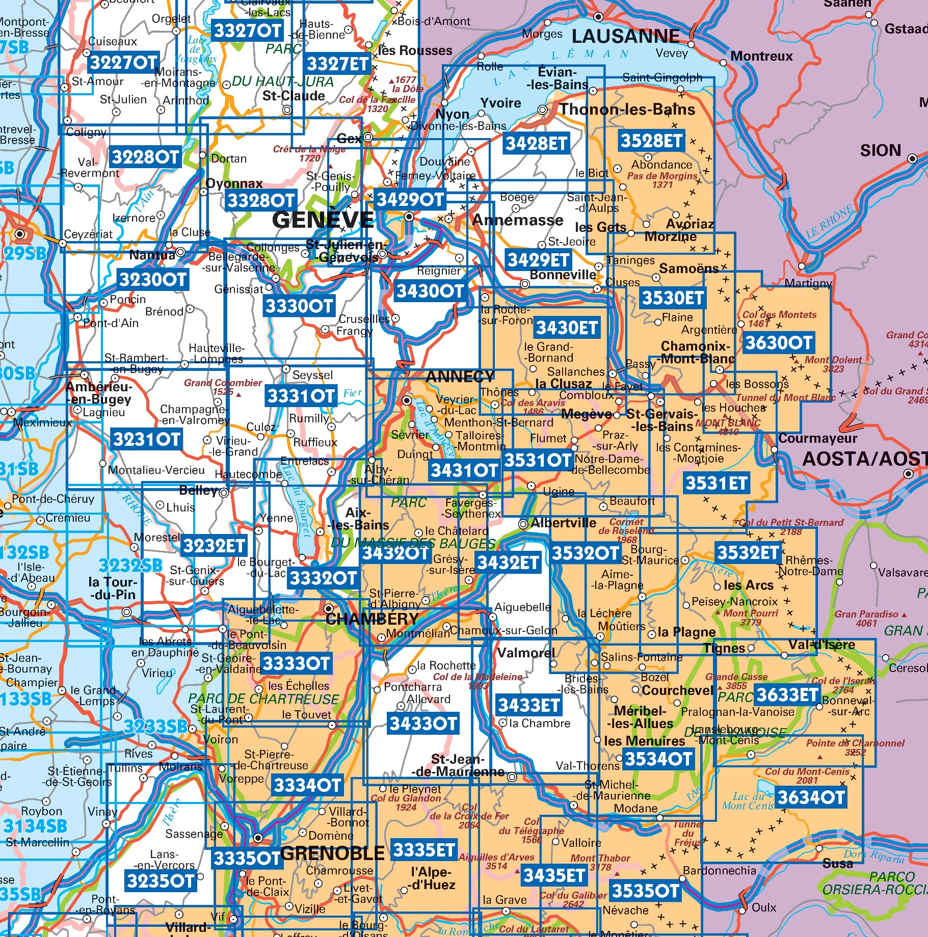
Producten op deze overzichtskaart:
Klik op een product om naar de pagina van dat product te gaan.
- Topografische kaart - Wandelkaart 3233 Le Grand-Lemps, Lac de Paladru, Voiron, Tullins | IGN - Institut Géographique National
- Wandelkaart - Topografische kaart 3333OT Massif de la Chartreuse Nord | IGN - Institut Géographique National
- Wandelkaart - Topografische kaart 3334OT Massif de la Chartreuse Sud | IGN - Institut Géographique National
- Wandelkaart - Topografische kaart 3335ET le Bourg d'Oisans - l'Alpe d'Huez | IGN - Institut Géographique National
- Wandelkaart - Topografische kaart 3335OT Grenoble | IGN - Institut Géographique National
- Wandelkaart - Topografische kaart 3335OTR Grenoble | IGN - Institut Géographique National
- Wandelkaart - Topografische kaart 3432ET Albertville | IGN - Institut Géographique National
- Wandelkaart - Topografische kaart 3432OT Massif des Bauges | IGN - Institut Géographique National
- Wandelkaart - Topografische kaart 3432OTR Massif des Bauges | IGN - Institut Géographique National
- Wandelkaart - Topografische kaart 3433ET Saint-Jean-de-Maurienne | IGN - Institut Géographique National
- Wandelkaart - Topografische kaart 3433OT Allevard | IGN - Institut Géographique National
- Wandelkaart - Topografische kaart 3435ET Valloire | IGN - Institut Géographique National
- Wandelkaart - Topografische kaart 3532ET les Arcs - la Plagne | IGN - Institut Géographique National
- Wandelkaart - Topografische kaart 3532OT Massif du Beaufortain | IGN - Institut Géographique National
- Wandelkaart - Topografische kaart 3534OT Les Trois Vallées | IGN - Institut Géographique National
- Wandelkaart - Topografische kaart 3535OT Névache - Mont Thabor | IGN - Institut Géographique National
- Wandelkaart - Topografische kaart 3633ET Tignes - Val d'Isère | IGN - Institut Géographique National
- Wandelkaart - Topografische kaart 3634OT Val Cenis | IGN - Institut Géographique National
Overzichtskaarten
Beschrijving
Reviews
Geen reviews gevonden voor dit product.
Schrijf een review
Graag horen wij wat u van dit artikel vindt. Vindt u het goed, leuk, mooi, slecht, lelijk, onbruikbaar of erg handig: schrijf gerust alles op! Het is niet alleen leuk om te doen maar u informeert andere klanten er ook nog mee!

