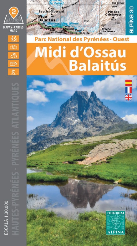
Wandelkaart Midi d'Ossau Balaitus | Editorial Alpina (9788470110948)
PN Pyrénées Ouest 2 maps
- ISBN / CODE: 9788470110948
- Editie: 06-03-2024
- Aantal blz.: 1
- Schaal: 1:30000
- Uitgever: Editorial Alpina
- Soort: Wandelkaart
- Taal: Engels, Spaans
- Hoogte: 21.0 cm
- Breedte: 12.0 cm
- Gewicht: 194.0 g
- Uitvoering: Papier
- Bindwijze: -
- Schrijf als eerste een review
-
€ 21,95
Leverbaar in 3 - 5 werkdagen in huis in Nederland Levertijd Belgie
Gratis verzending in Nederland vanaf €35,-


-
Overzicht Pyreneeën-West Editorial Alpina
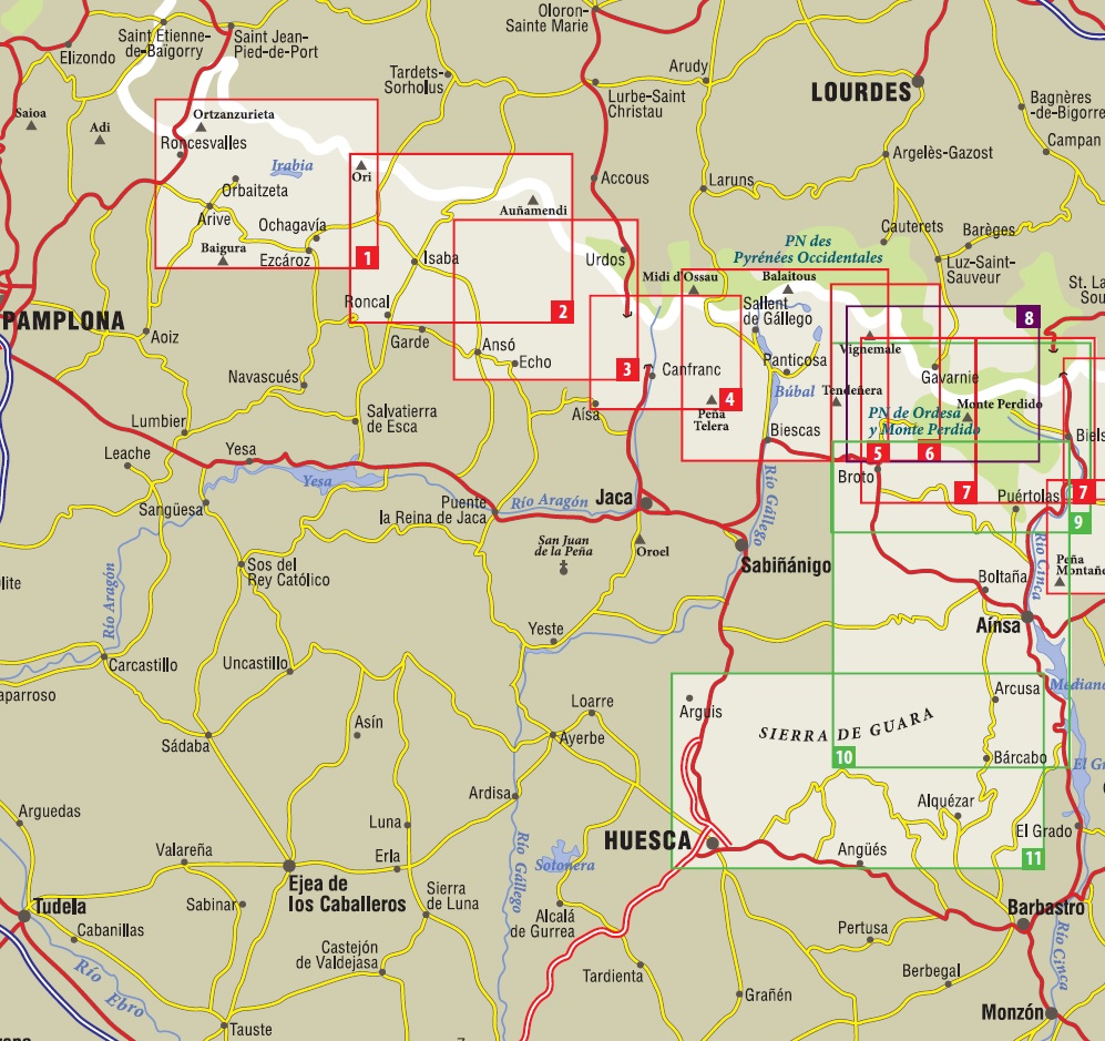
Producten op deze overzichtskaart:
Klik op een product om naar de pagina van dat product te gaan.
- Wandelkaart 01 Mapa de los Valles de Irati - Aezkoa (Roncesvalles) | Editorial Alpina
- Wandelkaart 02 Valles de Belagua y Roncal | Editorial Alpina
- Wandelkaart 03 Valles de Anso y Echo | Editorial Alpina
- Wandelkaart 04 Valle de Canfranc - Valle de Aisa | Editorial Alpina
- Wandelkaart 05 Valle de Tena | Editorial Alpina
- Wandelkaart 06 Vignemale - Valle de Bujaruelo | Editorial Alpina
- Wandelkaart 07 Parque Nacional Ordesa y Monte Perdido | Editorial Alpina
- Wandelkaart 09 Ordesa y Monte Perdido | Editorial Alpina
- Wandelkaart 10 Sobrabe Central - Aínsa - Boltaña | Editorial Alpina
- Wandelkaart 11 Sierra y Cañones de Guara, Canyons National Park | Editorial Alpina
- Wandelkaart Midi d'Ossau Balaitus | Editorial Alpina
- Wandelkaart Néouvielle | Editorial Alpina
- Wandelkaart Sobrepuerto | Editorial Alpina
Overzichtskaarten
Beschrijving
Van de uitgever
2 hiking maps in one folder
•Scale 1:25.000
•Equidistance contours: 10 m distance
•Master contours: at 50 m
•Shady relief
•Compatible with GPS
•Land use symbolized at three levels
The Parc National des Pyrénées stretches over one hundred kilometers, across six valleys, two departments (Pyrénées-Atlantiques and Hautes-Pyrénées), and two regions (Nouvelle-Aquitaine and Occitanie), along the border with Spain. These two maps cover the western sector of the park, with the massifs of Vignemale and Balaitús, and the peak of Midi d’Ossau.
Covered area: Parc National des Pyrénées. Pyrénées-Atlantiques and Hautes-Pyrénées. Midi d’Ossau, Balaitús, and Vignemale sector.
Map features: Two topographic maps, scale 1:30.000, with hiking and tourist information: Mountain huts, signposted footpaths (GR’s,
PR’s, local), routes to the summits, access to the starting points of the hikes, etc
The folding fl ap includes:
• 20 Hikes
• Geographic information
• The top 10 touristic highlights
Reviews
Geen reviews gevonden voor dit product.
Schrijf een review
Graag horen wij wat u van dit artikel vindt. Vindt u het goed, leuk, mooi, slecht, lelijk, onbruikbaar of erg handig: schrijf gerust alles op! Het is niet alleen leuk om te doen maar u informeert andere klanten er ook nog mee!
Ook interessant voor europa/frankrijk/atlantischekust
-

Wandelgids Midi-Pyrénées - - 100 pl
€ 21,50Wandelgidsen Midi-Pyrénées -

Wegenkaart - landkaart Pyrénées / Pi
€ 17,95Wegenkaarten Spaanse Pyreneeën -

Waterkaart Carlit 50 Estanys | Edito
€ 15,95Waterkaarten Spaanse Pyreneeën -

Reisgids The Basque Country and Nava
€ 22,50Reisgidsen Franse Atlantische Kust - Nouvelle-Aquitaine -

Wandelkaart 13 Cotiella - Pena Monta
€ 16,95Wandelkaarten Spaanse Pyreneeën