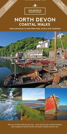
Wandelkaart North Devon coastal walks | Goldeneye (9781859652534)
- ISBN / CODE: 9781859652534
- Editie: 17-07-2017
- Druk: 3
- Aantal blz.: 1
- Uitgever: Goldeneye
- Soort: Wandelkaart
- Serie: walking maps
- Taal: Engels
- Hoogte: 24.0 cm
- Breedte: 12.0 cm
- Gewicht: 65.0 g
- Bindwijze: -
- Uitvoering: Scheur- en watervast
- Schrijf als eerste een review
-
€ 12,95
Leverbaar in 3 - 5 werkdagen in huis in Nederland Levertijd Belgie
Gratis verzending in Nederland vanaf €35,-
Beschrijving
Van de uitgever
North Devon is a rural landscape of small villages, rich pastures, secluded coves, long sandy beaches, and in its west and east corners, are high cliffs which fall precipitously to the sea. It is bordered, in the east, by the Exmoor National Park, and some of these walks are within the Park. In the middle section is Braunton Burrows, designated a World Heritage Site by UNESCO.
It is arguably one of the most beautiful corners of England. Much of the coastline is owned by the National Trust who protect and manage it for future generations. Inland the countryside is a tapestry of patchwork fields and high hedgerows protecting narrow country lanes. Stretching southwards from the two ports of Barnstaple and Bideford is a gentle pastoral countryside known as The Land of the Two Rivers (Torridge and Taw), which was so vividly brought to life in the works of Henry Williamson.
This is superb walking country: spectacular coastal views, long horizons inland towards Exmoor, a wealth of wildlife, wild flowers and old tracks. These routes were walked and researched in the winter after long spells of heavy rain, and are thus all passable throughout the year. Stout, waterproof footwear is advised although training shoes are adequate during the summer months. North Devon has a micro-climate of almost tropical dimensions. When it pours, it can pour in stair rods but when it clears, the sun shines brilliantly and the earth smells sweetly of the scent of grass and wild flowers.
The routes are in the main categorised as easy, easy-medium or medium, none are too difficult or strenuous. As they all follow part of the coastal footpath (which undulates), a modicum of fitness is necessary. The time allowed is generous. For the very fit subtract thirty minutes from each route. For the casual stroller add thirty minutes. Time for lunch or picnic stops have not been included. The design of our maps is such that we have bypassed the need, or use, of an Ordnance Survey map.
The Walks:
1. Combe Martin – Great Hangman
2. Heddon Valley – Trentishoe Down
3. Valley of Rocks
4. Lynmouth – Countisbury
5. Mortehoe – Lee
6. Saunton – Croyde – Putsborough
7. Braunton – Crow Point – Saunton
8. Hartland Quay – Titchberry
9. Clovelly – Brownsham 10. Buck’s Mills – Peppercombe
Reviews
Geen reviews gevonden voor dit product.
Schrijf een review
Graag horen wij wat u van dit artikel vindt. Vindt u het goed, leuk, mooi, slecht, lelijk, onbruikbaar of erg handig: schrijf gerust alles op! Het is niet alleen leuk om te doen maar u informeert andere klanten er ook nog mee!


